


I’ve lived in California (northern Cali and southern Cali) most of my life. One of the small towns I spent a few years in is called Indio; about an hour away from Joshua Tree National Park (JTNP). But as luck would have it, I only spent a few hours at the park on two occasions. It wasn’t until recently that I finally had the chance to go back and spend a few days exploring JTNP. I wanted to go camping but since this is desert, most of the camp sites do not have water. There are only two campsites that have water and they were full. We decided the best option would be to get an Airbnb close to the park entrance. We got a very cute place on Singletree Lane in Joshua Tree, less than 5 mins away from park entrance. I would definitely recommend it to anyone visiting JTNP.
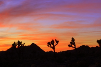
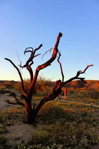
One of the first things we did was go to visitor center to pick up a map and their official newspaper which has some interesting articles and a lot of useful info about all the hikes. The exhibit at the visitor center is interesting and worth spending a few minutes. We drove around the park for a bit trying to find a nice place to watch the sunset. We settled on the Boy Scout Trail but we didn’t go very far from the north end of the trail. We spent 3 days at Joshua Tree and the sunset we saw on our first night was by far the best sunset I’ve seen. The sky put on such a
colorful show that night changing from blue to golden to orange to purple. The sight of Joshua Trees during such a colorful sunset is something everyone should experience. Once the sun was down, we had a few hours for stargazing. We drove to the Juniper Flats parking lot, first right after passing the Cap Rock RV parking lot. The location was great for stargazing but the problem was cloudy skies. We stayed around for over an hour, hoping the sky might clear up. Around 10 pm, we gave up on stargazing and went for dinner. On the drive back we saw a black-tailed jackrabbit and a coyote. I’m glad I was in the car when I saw the coyote.
 We had dinner at Castaneda’s Mexican food, a local Mexican chain restaurant that’s open 24 hours and it was closest to the airbnb. Their fish tacos are amazing. Chicken tacos and flautas were okay. Their carnitas burrito was very disappointing and I suggest not wasting your money on it. My recommendation is stick to their fish tacos.
JTNP is unique because its where two distinct desert ecosystems meet. Mojave desert is at higher elevation, slightly cooler and wetter whereas Colorado desert (part of Sonoran desert) is about 3,000 feet lower and encompasses Cholla cactus, Ocotillo, and other Creosote bush scrub. Colorado desert also has the only palm native to California, Fan Palm. The park’s elevation, dark skies, and dry desert air make it a great place for amateur astronomers.
As I mentioned before, I’ve visited the park for a short period of time but stayed mostly on the Mojave desert side. This time I wanted to go for a long hike on the Colorado desert side and didn’t want to waste time going for lunch somewhere outside the park. Going to a restaurant, even a fast food place, then returning to the park would have wasted hours and I preferred to use that time exploring the park instead. So the next morning

we woke up early to get some basics like fruits, granola bars, nuts, tortillas, eggs, cured meats and cheese from the grocery store. We ate a filling breakfast and made lunch to have on the trail before heading out to the park. This was a great decision because it saved us so much time once we got to the park. Some other things that really helped was to download the map of the area so we could use it if we didn’t have any data coverage. We also downloaded the Chimani Joshua Tree app which was very useful because soon after entering the park, you pretty much don’t have any data coverage. I have Verizon and within minutes of entering the park, I had no signal at all. The Chimani app is a great tool to have because it shows points of interests, picnic areas, hiking trails, scenic views, and much more. They have an app for every national park and I’m definitely going to download it for Yosemite and Sequoia National Parks.
After packing snacks, lunch, and downloading the Chimani app, we were ready to go for a long hike in Colorado desert side of the park. We drove through Park Blvd and turned onto Pinto Basin Road. Soon after passing the sign for White Tank Camping, the landscape changes. All of a sudden, there are no more Joshua Trees. I noticed a lot more green grass on the ground and wild flowers start to appear. This year was especially good because
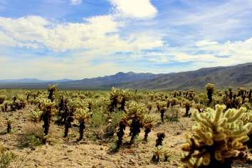
California had a lot of rain so everything was blooming. We made a quick stop at the Silver Bell Mine which operated between 1934 and 1962. It’s about 0.75 mile, relatively easy hike that offers great views. Our next stop was at Cholla Cactus Gardens which is just south of the merger between the upper Mojave desert and the lower Colorado desert. There is a quarter mile, very easy loop surrounded by these unique cacti nicknamed “teddy bear” cactus. They are found in the Colorado desert side because they need reliable water supply at certain times of the year. These cacti look really beautiful but their spines will stick to you with the slightest touch. They’ll latch on to clothes or skin so be careful.

Next stop on our way to Lost Palm Oasis hike, was Ocotillo patch. Ocotillo is actually not a cactus. It’s a woody deciduous plant that grow and drop leaves throughout the year, depending on rain. After a little rain, the Ocotillo starts growing leaves above each thorn and red blossoms appear above each cane. Photosynthesis continues until the next drought when the leaves turn brown and drop. These plants look so unique and unlike anything I’ve ever seen before in my life.
By the time we finally made it to Cottonwood Visitor Center it was around 1:00 pm. The Lost Palms Oasis hike is supposed to take 5-6 hours according to the JTNP official news paper. We wanted to make sure we had enough time to do the hike and come back before it got too dark. We asked the rangers at the visitor center and they said we’d have plenty of time. The only thing they recommended is to take plenty of water with us on the hike. They recommend about 1 gallon of water per person for the hike. So, we used the bathroom (one of the few with running water at the park), filled up our water bottles, applied lots of sunblock, and started on the hike. There’s very little shade on this hike so remember the sunblock!

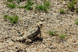
Lost Palms Oasis hike is a 7.2 mile, out and back, moderate hike. At the beginning of the hike I noticed there were three palm trees growing right next to each other, forming a natural canopy. Nature works in such amazing ways. The hike is very well marked and on the way we saw countless numbers of desert iguanas, Beavertail cactus, Ocotillo, colorful wildflowers, and even an adult male Chuckwalla – second largest lizard in USA. As you go through the trail, the landscape seems like it’s from another world entirely. There
are huge, almost orange, rocky mountains, small, green shrubs, and cacti everywhere. No wonder a lot of Star Trek episodes were filmed in this region. My favorite part of the hike was about half way to the Lost Palms Oasis. We walked past a ravine and there were a few areas of shade. At one point, I wasn’t sure if we were still on the trail. Chimani app and google maps helped confirm we were, indeed, on the trail. The hike is mostly flat and relatively easy until the last half a mile or so. The last part gets a little harder and since there are very few shady parts throughout the hike, I felt the effects of the heat.
We started the hike around 1:30 pm and by 3:30 pm we had reached the end of the marked trail (Lost Palms Canyon sign) which overlooks the Lost Palm Oasis. The actually oasis is about 500 feet below and that part of the trail is not maintained by park rangers. We did see a few people brave enough to go down the steep trail but we decided against it. From the top where the hike officially ends, you actually see two oasis made of Fan Palms. We managed to find a small, shady area behind a desert shrub where we had a small lunch “picnic” before heading back. Since you take the same path back, it goes by a lot faster. You don’t stop as much to look around and take pictures. You know whats coming and you are ready for it. We made it back to the parking lot by about 5:30 pm.

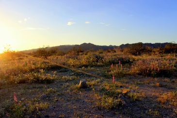
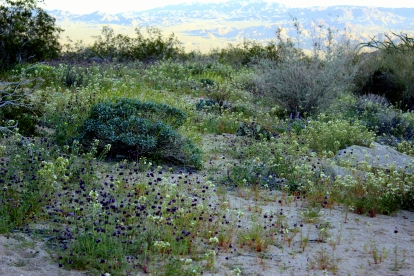
Since we still had a few hours of daylight left, we drove to Bajada Nature trail, a 0.3 mile walk, at the southern end of the park. Bajada means slope at a mountain’s base formed from eroded sand and gravel. This traps moisture which helps plants grow. Since California had a good amount of rain this year, there were wild flowers as far as the eye could see. Bajada trail also has many unique and interesting vegetation like the Palo Verde. This tree has green bark which is able to carry out photosynthesis! I’m not overly interested in trees but the nerd in me found this fascinating. Another plant we saw a lot in low desert with beautiful red flowers is called Chuparosa. It turns out this plant is only found in the Sonoran/Colorado desert, and the red, tubular flowers are to attract hummingbirds who pollinate the blossoms. This is another unique plant that can produce flowers and leaves all year round, depending on rain.
We watched sunset at the southern end of the park before driving north. We stopped at one of the pull off points to watch starts but it was starting to get very windy and I felt a bit cold in the Colorado desert side. After a few minutes of stargazing, we drove north and stopped again at Oyster Bay in Mojave desert side. It’s amazing how different the climate was just a few miles away in Mojave desert. There was no wind, skies were clear, and we were able to stargaze for over an hour. There was some ambient light from the ground but overall, this was the best night for stargazing. Lost boys trail and Cap Rock are also supposed to be great spots for stargazing. After 7.2 mile hike in heat and a few other smaller trails, we were both very tired and ready to call it a night.
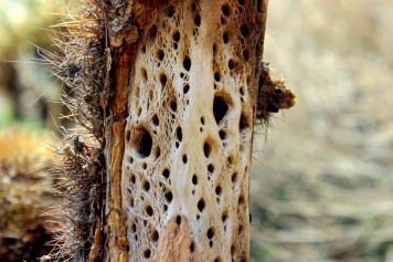
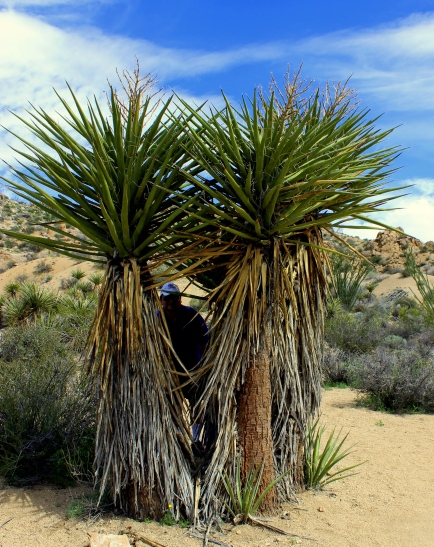
On our last day, we wanted to do a few short, easy hikes because we were still a little tired from the long, Lost Palms Oasis hike. Hidden Valley nature trail, one mile loop, was the first stop of the day. There are 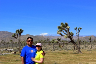 picnic tables near the big boulders and a few bathrooms, but no water. At the entrance of the trail, we met a volunteer named Mark Black. He spent most of his free time researching and learning about Joshua Trees. He spent 500 hours last year volunteering at JTNP. Joshua Trees don’t have typical, annual growth rings and they grow at an average rate of about 2-3 cm per year which helps calculate their age. For the first few decades, Joshua Tree grows vertically as a stem, without any branches. It gets about 5-10 feet high before it blossoms and can live for hundreds of years. The tallest Joshua Tree at JTNP is 40 feet high in Queen Valley forest. If I had signed up to volunteer, I could have spent a day with Mark Black roaming around the park, helping him collect data and do anything else he needed. I wish I knew this earlier; I would have signed up in a heart beat.
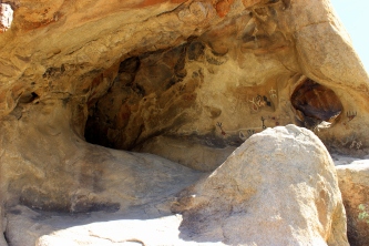
After talking with Mark Black for about an hour, we were finally ready to start the Hidden Valley nature trail. The valley is surrounded by huge rocks and mountains which protect it from wind and helps collect moisture, creating a unique and special micro-climate within the park. Hidden Valley is a transition zone between Joshua Tree forest and pinyon-juniper woodlands. Joshua trees grow in the center of the valley while oaks and pines grow near the rockier parts of the valley. The valley may have been used by cattle rustlers. It was an easy, nice, and leisurely trail. Next, we went to Baker Dam nature trail. I wanted to go on this trail because of the possibility of spotting bighorn sheep. Unfortunately, I’m not that lucky. Baker dam was built in 1900 by cowboys to water their cattle. When it rains, the reservoir fills with water and becomes a picturesque lake with huge boulders as the backdrop. As you continue to follow the trail, you come across a huge rock covered in petroglyphs. These petroglyphs were enhanced by film crew when filming some old Hollywood movie.

By the end of Baker dam trail, our feet were very sore. We decided we were done with hiking and walking around. The rest of the day we wanted to drive around the park. However, we had already driven through most of the paved roads in the park. We drove through non-paved, Queens Valley road which didn’t require a 4-wheel drive, to Geology Road tour. The little Toyota we had rented was good enough for Queens Valley road but Geology 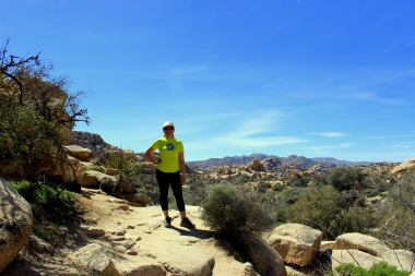 Road tour required 4-wheel drive. We had to cancel our plan of Geology Road tour and decided to get lunch at Artega’s Mexican Restaurant in Twentynine Palms. This place has good Mexican food for great price. I had their Chicharron corditas and it was delicious. After such a filling lunch, we went back to our Airbnb for some rest and relaxation. Plus, I noticed I was starting to get a mild sunburn even though I had used PLENTY of sunblock and reapplied it multiple times. I didn’t want to spend more time outside and make my sunburn worse.
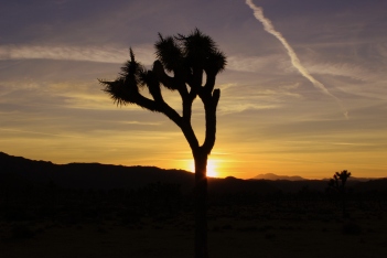
 We watched our last sunset at JTNP on the Mojave desert side. It was a beautiful sunset but nothing beat the sunset we saw on our first night. I’ve visited many national parks and every time I felt I could have used one more day. JTNP is the only exception. Three days at this park was just the right amount of time. There’s always more hiking we could have done but it’s VERY sunny and hot, even in March.
TIPS:
- Download the google map to use offline. Soon after entering the park, there’s no cell phone service so downloading the map on your phone can be really helpful when hiking.
- Download the Chimani app for Joshua Tree National Park. It has great information about hiking, biking, points of interests, scenic views, and other information. It gives short descriptions of all the hikes, camping sites, etc.
- Take LOTS of sunblock, sunglasses, and hats. It gets very sunny and hot during the daytime. Nights get a little cold in winter so also take a jacket.
- Try to volunteer for one day with Mark Black.
For more photos, please visit my instagram page: Rupal’s Travel Diaries


Loved this article. Very interesting and informative. All the pictures are great.